Staple
Staple ist eine französische Gemeinde im Département Nord in der Region Hauts-de-France. Sie gehört zum Arrondissement Dunkerque und zum Kanton Bailleul.
| Staple | ||
|---|---|---|
.svg.png.webp)
|
| |
| Staat | Frankreich | |
| Region | Hauts-de-France | |
| Département (Nr.) | Nord (59) | |
| Arrondissement | Dunkerque | |
| Kanton | Bailleul | |
| Gemeindeverband | Flandre Intérieure | |
| Koordinaten | 50° 45′ N, 2° 27′ O | |
| Höhe | 34–57 m | |
| Fläche | 9,97 km² | |
| Einwohner | 693 (1. Januar 2021) | |
| Bevölkerungsdichte | 70 Einw./km² | |
| Postleitzahl | 59190 | |
| INSEE-Code | 59577 | |
| Website | http://www.staple.fr/ | |
_mairie.JPG.webp) Mairie Staple | ||

Lage
Die Gemeinde Staple liegt in Französisch-Flandern am Südwestrand der Hügelkette Monts de Flandre, 13 Kilometer östlich von Saint-Omer. Sie grenzt im Nordwesten und Norden an Bavinchove, im Osten an Hondeghem, im Südosten an Wallon-Cappel (Berührungspunkt) und Lynde, im Südwesten an Ebblinghem und im Westen an Renescure (Berührungspunkt). An der südöstlichen Gemeindegrenze verläuft das Flüsschen Bourre, das hier noch Borre Becque genannt wird.
Bevölkerungsentwicklung
| Jahr | 1962 | 1968 | 1975 | 1982 | 1990 | 1999 | 2011 | 2021 |
| Einwohner | 648 | 624 | 570 | 549 | 624 | 610 | 694 | 693 |
| Quellen: Cassini und INSEE | ||||||||
Sehenswürdigkeiten
- Kirche Saint-Omer
- Kapelle Sainte-Anne
- Oratorien
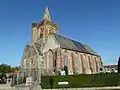 Kirche Saint-Omer
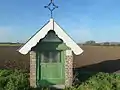 Kapelle Sainte-Anne
_monument_aux_morts.JPG.webp) Gefallenendenkmal
Gefallenendenkmal_oratoire_D161.JPG.webp) Oratorium
Oratorium
Literatur
- Le Patrimoine des Communes du Nord. Flohic Editions, Band 1, Paris 2001, ISBN 2-84234-119-8, S. 847–849.
Weblinks
Commons: Staple (Nord) – Sammlung von Bildern
- Monuments historiques (Objekte) in Staple in der Base Palissy des französischen Kultusministeriums
This article is issued from Wikipedia. The text is licensed under Creative Commons - Attribution - Sharealike. Additional terms may apply for the media files.