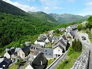
Saint-Aventin
Saint-Aventin ist eine französische Gemeinde mit 60 Einwohnern (Stand: 1. Januar 2021) im Département Haute-Garonne in der Region Okzitanien. Sie gehört zum Arrondissement Saint-Gaudens und zum Kanton Bagnères-de-Luchon.
| Saint-Aventin | ||
|---|---|---|
.svg.png.webp)
|
| |
| Staat | Frankreich | |
| Region | Okzitanien | |
| Département (Nr.) | Haute-Garonne (31) | |
| Arrondissement | Saint-Gaudens | |
| Kanton | Bagnères-de-Luchon | |
| Gemeindeverband | Communauté de communes Pyrénées Haut Garonnaises | |
| Koordinaten | 42° 48′ N, 0° 33′ O | |
| Höhe | 679–2676 m | |
| Fläche | 17,40 km² | |
| Einwohner | 60 (1. Januar 2021) | |
| Bevölkerungsdichte | 3 Einw./km² | |
| Postleitzahl | 31110 | |
| INSEE-Code | 31470 | |
 Saint-Aventin | ||

Geografie
Die Gemeinde liegt in den Pyrenäen. Durch Saint-Aventin fließt die Neste d’Oô. Nachbargemeinden sind Billière (Berührungspunkt) im Nordwesten, Benque-Dessous-et-Dessus im Norden, Trébons-de-Luchon und Cazarilh-Laspènes im Nordosten, Bagnères-de-Luchon im Osten, Benasque in Spanien im Süden und Castillon-de-Larboust im Westen.
Bevölkerungsentwicklung
| Jahr | 1962 | 1968 | 1975 | 1982 | 1990 | 1999 | 2008 | 2015 | 2019 |
|---|---|---|---|---|---|---|---|---|---|
| Einwohner | 128 | 155 | 149 | 115 | 98 | 95 | 88 | 105 | 64 |
| Quelle: Cassini und INSEE | |||||||||
Sehenswürdigkeiten
- Kirche St-Aventin-de-Larboust (Monument historique), erbaut im 12. Jahrhundert
Siehe auch: Liste der Monuments historiques in Saint-Aventin
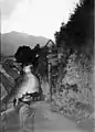 Saint-Aventin im September 1898
.jpg.webp) Kapelle
Kapelle.JPG.webp) Kirche St-Aventin-de-Larboust
Kirche St-Aventin-de-Larboust Das zu Saint-Aventin gehörende Skigebiet Luchon-Superbagnères
Literatur
- Le Patrimoine des Communes de la Haute-Garonne. Flohic Editions, Band 1, Paris 2000, ISBN 2-84234-081-7, S. 285–290.
This article is issued from Wikipedia. The text is licensed under Creative Commons - Attribution - Sharealike. Additional terms may apply for the media files.