Saint-André-de-Cruzières
Saint-André-de-Cruzières ist eine französische Gemeinde mit 462 Einwohnern (Stand 1. Januar 2021) im französischen Département Ardèche.
| Saint-André-de-Cruzières | ||
|---|---|---|
| ||
| Staat | Frankreich | |
| Region | Auvergne-Rhône-Alpes | |
| Département (Nr.) | Ardèche (07) | |
| Arrondissement | Largentière | |
| Kanton | Les Cévennes Ardéchoises | |
| Gemeindeverband | Pays des Vans en Cévennes | |
| Koordinaten | 44° 19′ N, 4° 13′ O | |
| Höhe | 152–431 m | |
| Fläche | 19,81 km² | |
| Einwohner | 462 (1. Januar 2021) | |
| Bevölkerungsdichte | 23 Einw./km² | |
| Postleitzahl | 07460 | |
| INSEE-Code | 07211 | |
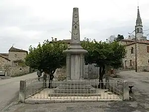 Kriegerdenkmal in der Ortsmitte | ||

Geographie
Saint-André-de-Cruzières liegt im Tal des Flusses Claysse, am Fuße der Cevennen, im Süden des Départements. Die nächstgrößere Stadt ist Alès in etwa 20 Kilometern Entfernung Richtung Südwesten.
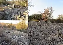
Dolmens von Chadouilletin Saint-André-de-Cruzières
Bevölkerung
| Jahr | 1968 | 1975 | 1982 | 1990 | 1999 | 2007 | 2017 |
|---|---|---|---|---|---|---|---|
| Einwohner | 425 | 403 | 411 | 383 | 425 | 521 | 464 |
| Quellen: Cassini und INSEE | |||||||
Weblinks
Commons: Saint-André-de-Cruzières – Sammlung von Bildern, Videos und Audiodateien
This article is issued from Wikipedia. The text is licensed under Creative Commons - Attribution - Sharealike. Additional terms may apply for the media files.