Saint-Amant-de-Nouère
Saint-Amant-de-Nouère ist eine westfranzösische Gemeinde mit 354 Einwohnern (Stand 1. Januar 2021) im Département Charente in der Region Nouvelle-Aquitaine (vor 2016 Poitou-Charentes). Sie gehört zum Arrondissement Cognac (bis 2017 Angoulême) und zum Kanton Val de Nouère.
| Saint-Amant-de-Nouère | ||
|---|---|---|
| ||
| Staat | Frankreich | |
| Region | Nouvelle-Aquitaine | |
| Département (Nr.) | Charente (16) | |
| Arrondissement | Cognac | |
| Kanton | Val de Nouère | |
| Gemeindeverband | Rouillacais | |
| Koordinaten | 45° 45′ N, 0° 0′ O | |
| Höhe | 62–132 m | |
| Fläche | 11,15 km² | |
| Einwohner | 354 (1. Januar 2021) | |
| Bevölkerungsdichte | 32 Einw./km² | |
| Postleitzahl | 16170 | |
| INSEE-Code | 16298 | |
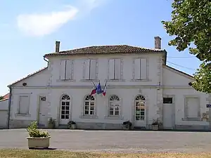 Rathaus (Mairie) von Saint-Amant-de-Nouère | ||

Lage
Saint-Amant-de-Nouère liegt etwa 15 Kilometer nordwestlich von Angoulême in der Kulturlandschaft des Angoumois. Der Fluss Nouère begrenzt die Gemeinde im Osten. Umgeben wird Saint-Amant-de-Nouère von den Nachbargemeinden Saint-Cybardeaux im Norden und Nordwesten, Saint-Genis-d’Hiersac im Osten, Asnières-sur-Nouère im Südosten, Douzat im Süden sowie Échallat im Westen.
Bevölkerungsentwicklung
| Jahr | 1962 | 1968 | 1975 | 1982 | 1990 | 1999 | 2006 | 2019 |
| Einwohner | 359 | 352 | 331 | 350 | 372 | 382 | 380 | 373 |
| Quellen: Cassini und INSEE | ||||||||
Sehenswürdigkeiten
- Kirche Saint-Amant
- Schloss und Domäne Fontguyon, 1570 erbaut, seit 1989/1994 Monument historique
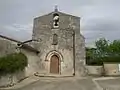 Kirche Saint-Amant
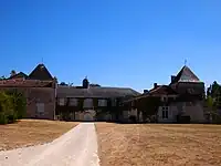 Schloss Fontguyon
Weblinks
Commons: Saint-Amant-de-Nouère – Sammlung von Bildern, Videos und Audiodateien
This article is issued from Wikipedia. The text is licensed under Creative Commons - Attribution - Sharealike. Additional terms may apply for the media files.