Kanton Conches-en-Ouche
Der Kanton Conches-en-Ouche ist ein französischer Wahlkreis im Arrondissement Évreux, im Département Eure und in der Region Normandie; sein Hauptort ist Conches-en-Ouche.
| Kanton Conches-en-Ouche | |
|---|---|
| Region | Normandie |
| Département | Eure |
| Arrondissement | Évreux |
| Hauptort | Conches-en-Ouche |
| Einwohner | 21.060 (1. Jan. 2021) |
| Bevölkerungsdichte | 70 Einw./km² |
| Fläche | 302,89 km² |
| Gemeinden | 29 |
| INSEE-Code | 2708 |
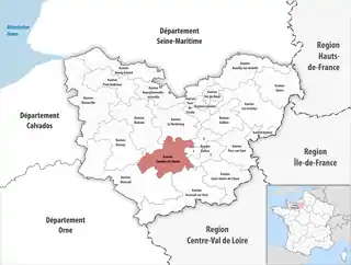 Lage des Kantons Conches-en-Ouche im Département Eure | |
Der Kanton Conches-en-Ouche ist 302,89 km² groß und hat (2021) 21.060 Einwohner, was einer Bevölkerungsdichte von 70 Einwohnern pro km² entspricht. Er liegt im Mittel 153 Meter über Normalnull, zwischen 76 Meter in La Bonneville-sur-Iton und 192 Meter in Beaubray.
Gemeinden
Der Kanton besteht aus 29 Gemeinden mit insgesamt 21.060 Einwohnern (Stand: 1. Januar 2021) auf einer Gesamtfläche von 302,89 km²:
| Gemeinde | Einwohner 1. Januar 2021 |
Fläche km² |
Dichte Einw./km² |
Code INSEE |
Postleitzahl |
|---|---|---|---|---|---|
| Aulnay-sur-Iton | 709 | 1,53 | 463 | 27023 | 27180 |
| Beaubray | 336 | 15,43 | 22 | 27047 | 27190 |
| Burey | 404 | 5,40 | 75 | 27120 | 27190 |
| Caugé | 831 | 11,61 | 72 | 27132 | 27180 |
| Champ-Dolent | 62 | 2,28 | 27 | 27141 | 27190 |
| Claville | 1.074 | 17,66 | 61 | 27161 | 27180 |
| Collandres-Quincarnon | 242 | 7,98 | 30 | 27162 | 27190 |
| Conches-en-Ouche | 4.905 | 16,72 | 293 | 27165 | 27190 |
| Faverolles-la-Campagne | 160 | 4,71 | 34 | 27235 | 27190 |
| Ferrières-Haut-Clocher | 1.140 | 11,38 | 100 | 27238 | 27190 |
| Gaudreville-la-Rivière | 221 | 6,73 | 33 | 27281 | 27190 |
| Gauville-la-Campagne | 633 | 6,15 | 103 | 27282 | 27930 |
| Glisolles | 865 | 10,92 | 79 | 27287 | 27190 |
| La Bonneville-sur-Iton | 2.046 | 4,00 | 512 | 27082 | 27190 |
| La Croisille | 417 | 5,40 | 77 | 27189 | 27190 |
| La Ferrière-sur-Risle | 211 | 0,24 | 879 | 27240 | 27760 |
| Le Fidelaire | 1.007 | 33,55 | 30 | 27242 | 27190 |
| Les Ventes | 1.045 | 20,65 | 51 | 27678 | 27180 |
| Le Val-Doré | 885 | 20,17 | 44 | 27447 | 27190 |
| Louversey | 514 | 10,73 | 48 | 27374 | 27190 |
| Nagel-Séez-Mesnil | 331 | 11,72 | 28 | 27424 | 27190 |
| Nogent-le-Sec | 435 | 10,11 | 43 | 27436 | 27190 |
| Ormes | 470 | 14,10 | 33 | 27446 | 27190 |
| Parville | 289 | 4,54 | 64 | 27451 | 27180 |
| Portes | 265 | 9,44 | 28 | 27472 | 27190 |
| Saint-Élier | 415 | 2,32 | 179 | 27535 | 27190 |
| Sainte-Marthe | 491 | 17,50 | 28 | 27568 | 27190 |
| Sébécourt | 463 | 14,80 | 31 | 27618 | 27190 |
| Tilleul-Dame-Agnès | 194 | 5,12 | 38 | 27640 | 27170 |
| Kanton Conches-en-Ouche | 21.060 | 302,89 | 70 | 2708 | – |
Bis zur Neuordnung bestand der Kanton Conches-en-Ouche aus den 25 Gemeinden Beaubray, La Bonneville-sur-Iton, Burey, Champ-Dolent, Collandres-Quincarnon, Conches-en-Ouche, La Croisille, Émanville, Faverolles-la-Campagne, Ferrières-Haut-Clocher, La Ferrière-sur-Risle, Le Fidelaire, Le Fresne, Gaudreville-la-Rivière, Glisolles, Louversey, Le Mesnil-Hardray, Nagel-Séez-Mesnil, Nogent-le-Sec, Ormes, Orvaux, Portes, Saint-Élier, Sainte-Marthe und Sébécourt. Sein Zuschnitt entsprach einer Fläche von 160,51 km2.
Veränderungen im Gemeindebestand seit der landesweiten Neuordnung der Kantone
2018: Fusion Le Fresne, Le Mesnil-Hardray und Orvaux → Le Val-Doré