Chenières
Chenières ist eine französische Gemeinde mit 610 Einwohnern (Stand: 1. Januar 2021) im Département Meurthe-et-Moselle in der Region Grand Est (bis 2015 Lothringen). Sie gehört zum Arrondissement Val-de-Briey und ist Mitglied im Gemeindeverband Grand Longwy Agglomération.
| Chenières | ||
|---|---|---|
|
| |
| Staat | Frankreich | |
| Region | Grand Est | |
| Département (Nr.) | Meurthe-et-Moselle (54) | |
| Arrondissement | Val-de-Briey | |
| Kanton | Longwy | |
| Gemeindeverband | Grand Longwy Agglomération | |
| Koordinaten | 49° 28′ N, 5° 46′ O | |
| Höhe | 274–398 m | |
| Fläche | 8,50 km² | |
| Einwohner | 610 (1. Januar 2021) | |
| Bevölkerungsdichte | 72 Einw./km² | |
| Postleitzahl | 54720 | |
| INSEE-Code | 54127 | |
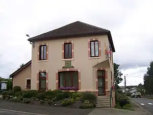 Bürgermeisteramt (Mairie) | ||

Geografie
Die Gemeinde Chenières liegt etwa 41 Kilometer westnordwestlich von Thionville. Nachbargemeinden von Chenières sind Réhon im Norden, Mexy im Norden und Nordosten, Haucourt-Moulaine im Nordosten und Osten, Villers-la-Montagne im Osten, Laix im Süden, Baslieux im Süden und Südwesten, Ugny im Südwesten und Westen sowie Cutry im Westen und Nordwesten.
Bevölkerungsentwicklung
| Jahr | 1962 | 1968 | 1975 | 1982 | 1990 | 1999 | 2006 | 2019 |
| Einwohner | 342 | 431 | 466 | 452 | 512 | 531 | 578 | 631 |
| Quellen: Cassini und INSEE | ||||||||
Sehenswürdigkeiten
- Kirche Saint-Loup aus dem 19. Jahrhundert
- Ehemalige Wasserpumpe
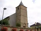 Kirche Saint-Loup
_pompe.JPG.webp) Ehemalige Wasserpumpe
Ehemalige Wasserpumpe
Weblinks
Commons: Chenières – Sammlung von Bildern
This article is issued from Wikipedia. The text is licensed under Creative Commons - Attribution - Sharealike. Additional terms may apply for the media files.