Charentilly
Charentilly ist eine französische Gemeinde mit 1.336 Einwohnern (Stand: 1. Januar 2021) im Département Indre-et-Loire in der Region Centre-Val de Loire; sie gehört zum Arrondissement Chinon und zum Kanton Château-Renault. Die Einwohner werden Charentillais und Charentillaises genannt.
| Charentilly | ||
|---|---|---|
.svg.png.webp)
|
| |
| Staat | Frankreich | |
| Region | Centre-Val de Loire | |
| Département (Nr.) | Indre-et-Loire (37) | |
| Arrondissement | Chinon | |
| Kanton | Château-Renault | |
| Gemeindeverband | Gâtine-Racan | |
| Koordinaten | 47° 28′ N, 0° 37′ O | |
| Höhe | 73–122 m | |
| Fläche | 14,13 km² | |
| Einwohner | 1.336 (1. Januar 2021) | |
| Bevölkerungsdichte | 95 Einw./km² | |
| Postleitzahl | 37390 | |
| INSEE-Code | 37059 | |
| Website | charentilly.fr | |

Geographie
Die Gemeinde Charentilly liegt an der Petite Choisille, etwa zehn Kilometer nordnordwestlich von Tours. Umgeben wird Charentilly von den Nachbargemeinden Semblançay im Westen und Norden, Saint-Antoine-du-Rocher im Nordosten und Osten, La Membrolle-sur-Choisille im Südosten, Fondettes im Süden sowie Saint-Roch im Südwesten und Westen.
Bevölkerungsentwicklung
| Jahr | 1962 | 1968 | 1975 | 1982 | 1990 | 1999 | 2006 | 2013 | 2021 |
| Einwohner | 449 | 443 | 509 | 641 | 855 | 987 | 1030 | 1202 | 1336 |
| Quellen: Cassini und INSEE | |||||||||
Sehenswürdigkeiten
- Kirche Saint-Laurent mit Ursprüngen aus dem 12. Jahrhundert, Monument historique
- Schloss Poillé aus dem Jahr 1830
- ehemaliges Herrenhaus (Manoir des Ligneries) aus dem 15. Jahrhundert, in Teilen Monument historique
_(29734953601).jpg.webp) Schloss Charentilly
Schloss Charentilly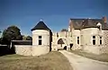 Ehemaliges Herrenhaus
Literatur
- Le Patrimoine des Communes d’Indre-et-Loire. Flohic Editions, Band 2, Paris 2001, ISBN 2-84234-115-5, S. 1019–1022.
This article is issued from Wikipedia. The text is licensed under Creative Commons - Attribution - Sharealike. Additional terms may apply for the media files.