Virsac
Virsac ist eine französische Gemeinde mit 1.305 Einwohnern (Stand: 1. Januar 2021) im Département Gironde in der Region Nouvelle-Aquitaine. Sie gehört zum Arrondissement Blaye und zum Kanton Le Nord-Gironde. Die Einwohner werden Virsacais genannt.
| Virsac | ||
|---|---|---|
| ||
| Staat | Frankreich | |
| Region | Nouvelle-Aquitaine | |
| Département (Nr.) | Gironde (33) | |
| Arrondissement | Blaye | |
| Kanton | Le Nord-Gironde | |
| Gemeindeverband | Grand Cubzaguais | |
| Koordinaten | 45° 2′ N, 0° 26′ W | |
| Höhe | 33–56 m | |
| Fläche | 3,60 km² | |
| Einwohner | 1.305 (1. Januar 2021) | |
| Bevölkerungsdichte | 363 Einw./km² | |
| Postleitzahl | 33240 | |
| INSEE-Code | 33553 | |
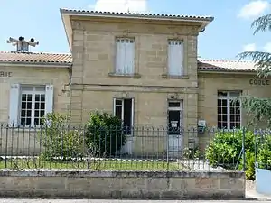 Rathaus von Virsac | ||

Geografie
Virsac liegt etwa 23 Kilometer nordnordöstlich von Bordeaux. Umgeben wird Virsac von den Nachbargemeinden Peujard im Norden, Val de Virvée im Osten und Südosten, Saint-André-de-Cubzac im Süden, Saint-Gervais im Südwesten und Westen sowie Saint-Laurent-d’Arce im Nordwesten.
Durch die Gemeinde führt die Autoroute A10 (mit der Mautstation Virsac) und die Route nationale 10 am Ostrand der Gemeinde.
Bevölkerungsentwicklung
| Jahr | 1962 | 1968 | 1975 | 1982 | 1990 | 1999 | 2008 | 2020 |
| Einwohner | 327 | 341 | 407 | 593 | 926 | 901 | 969 | 1262 |
| Quellen: Cassini und INSEE | ||||||||
Sehenswürdigkeiten
- romanische Kirche Saint-Genès, im 11./12. Jahrhundert errichtet, seit 1974 Monument historique
- Schloss Bois Martin, Ende des 16. Jahrhunderts erbaut
- Schloss Julie
 Kirche Saint-Genès
 Friedhofskreuz
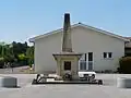 Gefallenendenkmal
Literatur
- Le Patrimoine des Communes de la Gironde. Flohic Éditions, Band 2, Paris 2001, ISBN 2-84234-125-2, S. 1252.
Weblinks
Commons: Virsac – Sammlung von Bildern
This article is issued from Wikipedia. The text is licensed under Creative Commons - Attribution - Sharealike. Additional terms may apply for the media files.