Virelade
Virelade ist eine französische Gemeinde mit 1109 Einwohnern (Stand 1. Januar 2021) im Département Gironde in der Region Nouvelle-Aquitaine.
| Virelade | ||
|---|---|---|
.svg.png.webp)
|
| |
| Staat | Frankreich | |
| Region | Nouvelle-Aquitaine | |
| Département (Nr.) | Gironde (33) | |
| Arrondissement | Langon | |
| Kanton | Les Landes des Graves | |
| Gemeindeverband | Convergence Garonne | |
| Koordinaten | 44° 40′ N, 0° 23′ W | |
| Höhe | 4–31 m | |
| Fläche | 13,41 km² | |
| Einwohner | 1.109 (1. Januar 2021) | |
| Bevölkerungsdichte | 83 Einw./km² | |
| Postleitzahl | 33720 | |
| INSEE-Code | 33552 | |
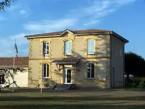 Mairie (Rathaus) | ||

Die Gemeinde liegt am linken Ufer der Garonne.
Die nächsten Nachbargemeinden sind Arbanats im Nordwesten und Podensac im Südosten.
Auf der Gemeindegemarkung existieren Überreste einer galloromanischen Villa, eine Motte und eine Burg.
Bevölkerungsentwicklung
| Jahr | 1962 | 1968 | 1975 | 1982 | 1990 | 1999 | 2007 | 2014 |
|---|---|---|---|---|---|---|---|---|
| Einwohner | 552 | 559 | 646 | 727 | 734 | 749 | 875 | 1030 |
Sehenswürdigkeiten

Kirche Sainte-Marie
- Kirche Sainte-Marie
- Siehe auch: Liste der Monuments historiques in Virelade
Literatur
- Le Patrimoine des Communes de la Gironde. Flohic Éditions, Band 2, Paris 2001, ISBN 2-84234-125-2, S. 1152–1153.
This article is issued from Wikipedia. The text is licensed under Creative Commons - Attribution - Sharealike. Additional terms may apply for the media files.