Sixt-sur-Aff
Sixt-sur-Aff (bretonisch: Seizh; Gallo: Sitz) ist eine französische Gemeinde mit 2.163 Einwohnern (Stand: 1. Januar 2021) im Département Ille-et-Vilaine in der Region Bretagne; sie gehört zum Arrondissement Redon und zum Kanton Redon. Die Einwohner werden Sixtins genannt.
| Sixt-sur-Aff Seizh | ||
|---|---|---|
.svg.png.webp)
|
| |
| Staat | Frankreich | |
| Region | Bretagne | |
| Département (Nr.) | Ille-et-Vilaine (35) | |
| Arrondissement | Redon | |
| Kanton | Redon | |
| Gemeindeverband | Redon Agglomération | |
| Koordinaten | 47° 47′ N, 2° 5′ W | |
| Höhe | 5–92 m | |
| Fläche | 42,50 km² | |
| Einwohner | 2.163 (1. Januar 2021) | |
| Bevölkerungsdichte | 51 Einw./km² | |
| Postleitzahl | 35550 | |
| INSEE-Code | 35328 | |
| Website | https://sixt-sur-aff.fr/ | |
 Rathaus (Mairie) von Sixt-sur-Aff | ||

Geographie
Die Gemeinde Sixt-sur-Aff liegt 13 Kilometer nördlich von Redon am Fluss Aff, der hier die Grenze zum Département Morbihan bildet. Umgeben wird Sixt-sur-Aff von den Nachbargemeinden Carentoir und Quelneuc im Norden, Bruc-sur-Aff im Nordosten, Saint-Just im Osten, Renac im Südosten, Bains-sur-Oust im Süden, Cournon im Süden und Südwesten sowie La Gacilly im Westen.
Bevölkerungsentwicklung
| Jahr | 1962 | 1968 | 1975 | 1982 | 1990 | 1999 | 2006 | 2013 | 2020 |
| Einwohner | 1838 | 1722 | 1713 | 1848 | 1885 | 1915 | 2050 | 2105 | 2144 |
| Quellen: Cassini und INSEE | |||||||||
Sehenswürdigkeiten
- Kirche Saint-Sixte
- Kapelle Sainte-Anne-de-Noyal
 Kirche Saint-Sixte
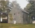 Kapelle Sainte-Anne-de-Noyal
Literatur
- Le Patrimoine des Communes d’Ille-et-Vilaine. Flohic Editions, Band 2, Paris 2000, ISBN 2-84234-072-8, S. 1063–1067.
Weblinks
Commons: Sixt-sur-Aff – Sammlung von Bildern
This article is issued from Wikipedia. The text is licensed under Creative Commons - Attribution - Sharealike. Additional terms may apply for the media files.