Salmiech
Salmiech (okzitanisch: Saumièg) ist eine französische Gemeinde mit 759 Einwohnern (Stand: 1. Januar 2021) im Département Aveyron in der Region Okzitanien. Sie gehört zum Arrondissement Millau und zum Kanton Monts du Réquistanais. Die Einwohner werden Salmiéchois genannt.
| Salmiech Saumièg | ||
|---|---|---|
| ||
| Staat | Frankreich | |
| Region | Okzitanien | |
| Département (Nr.) | Aveyron (12) | |
| Arrondissement | Millau | |
| Kanton | Monts du Réquistanais | |
| Gemeindeverband | Pays de Salars | |
| Koordinaten | 44° 11′ N, 2° 34′ O | |
| Höhe | 517–846 m | |
| Fläche | 28,16 km² | |
| Einwohner | 759 (1. Januar 2021) | |
| Bevölkerungsdichte | 27 Einw./km² | |
| Postleitzahl | 12120 | |
| INSEE-Code | 12255 | |
| Website | https://www.salmiech.fr/ | |
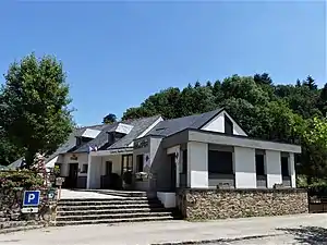 Mairie Salmiech | ||

Geographie
Salmiech liegt rund 37 Kilometer nordöstlich von Albi und etwa 19 Kilometer südlich von Rodez am Céor. Nachbargemeinden sind Comps-la-Grand-Ville im Norden, Trémouilles im Nordosten, Arvieu im Osten, Auriac-Lagast im Süden sowie Cassagnes-Bégonhès im Westen.
Bevölkerungsentwicklung
| Jahr | 1962 | 1968 | 1975 | 1982 | 1990 | 1999 | 2006 | 2019 |
| Einwohner | 982 | 951 | 864 | 741 | 671 | 728 | 703 | 766 |
| Quellen: Cassini und INSEE | ||||||||
Sehenswürdigkeiten
- Kirche Saint-Amans, Monument historique
- frühere Kirche Saint-Firmin, heutiges Museum Le Charroi Rural
- Kirche Saint-Étienne im Ortsteil Carcenac
- Schloss Salmiech
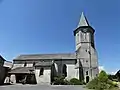 Kirche Saint-Amans
.jpg.webp) Exponat im Museum Le Charroi Rural
Exponat im Museum Le Charroi Rural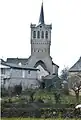 Kirche Saint-Étienne
Weblinks
Commons: Salmiech – Sammlung von Bildern, Videos und Audiodateien
This article is issued from Wikipedia. The text is licensed under Creative Commons - Attribution - Sharealike. Additional terms may apply for the media files.