Sainte-Eanne
Sainte-Eanne ist eine französische Gemeinde mit 603 Einwohnern (Stand: 1. Januar 2021) im Département Deux-Sèvres in der Region Nouvelle-Aquitaine (vor 2016: Poitou-Charentes). Sie gehört zum Arrondissement Niort und zum Kanton Saint-Maixent-l’École. Die Einwohner werden Emmeranais genannt.
| Sainte-Eanne | ||
|---|---|---|
| ||
| Staat | Frankreich | |
| Region | Nouvelle-Aquitaine | |
| Département (Nr.) | Deux-Sèvres (79) | |
| Arrondissement | Niort | |
| Kanton | Saint-Maixent-l’École | |
| Gemeindeverband | Haut Val de Sèvre | |
| Koordinaten | 46° 24′ N, 0° 8′ W | |
| Höhe | 60–159 m | |
| Fläche | 13,83 km² | |
| Einwohner | 603 (1. Januar 2021) | |
| Bevölkerungsdichte | 44 Einw./km² | |
| Postleitzahl | 79800 | |
| INSEE-Code | 79246 | |

Geographie
Sainte-Eanne liegt etwa 23 Kilometer ostnordöstlich von Niort am Pamproux. Umgeben wird Sainte-Eanne von den Nachbargemeinden Nanteuil im Norden, Soudan im Nordosten, Salles im Osten, La Mothe-Saint-Héray im Süden, Souvigné im Südwesten sowie Saint-Martin-de-Saint-Maixent im Westen.
Bevölkerungsentwicklung
| Jahr | 1962 | 1968 | 1975 | 1982 | 1990 | 1999 | 2006 | 2019 |
| Einwohner | 550 | 532 | 518 | 552 | 627 | 594 | 642 | 605 |
| Quellen: Cassini und INSEE | ||||||||
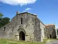 Kirche Saint Emmeran
 Schloss Villedieu-de-Comblé
Weblinks
Commons: Sainte-Eanne – Sammlung von Bildern, Videos und Audiodateien
This article is issued from Wikipedia. The text is licensed under Creative Commons - Attribution - Sharealike. Additional terms may apply for the media files.