Saint-Marcel (Morbihan)
Saint-Marcel (Gallo Saent-Marcèu, bretonisch Sant-Marc’hell) ist eine französische Gemeinde mit 1.127 Einwohnern (Stand 1. Januar 2021) im Département Morbihan in der Region Bretagne.
| Saint-Marcel Saent-Marcèu | ||
|---|---|---|
| ||
| Staat | Frankreich | |
| Region | Bretagne | |
| Département (Nr.) | Morbihan (56) | |
| Arrondissement | Vannes | |
| Kanton | Moréac | |
| Gemeindeverband | De l’Oust à Brocéliande Communauté | |
| Koordinaten | 47° 48′ N, 2° 25′ W | |
| Höhe | 12–112 m | |
| Fläche | 12,81 km² | |
| Einwohner | 1.127 (1. Januar 2021) | |
| Bevölkerungsdichte | 88 Einw./km² | |
| Postleitzahl | 56140 | |
| INSEE-Code | 56228 | |
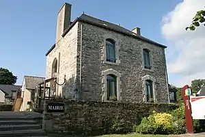 das Rathaus (Mairie) von Saint-Marcel | ||

Geografie
Saint-Marcel liegt rund 31 Kilometer nordöstlich von Vannes im Osten des Départements Morbihan. Nachbargemeinden sind Saint-Abraham im Norden, Missiriac im Nordosten, Malestroit im Osten, Pleucadeuc im Südosten, Bohal im Südwesten sowie Sérent im Westen.
Unweit liegt die Allée couverte von Trélan.
Bevölkerungsentwicklung
| Jahr | 1962 | 1968 | 1975 | 1982 | 1990 | 1999 | 2006 | 2012 | 2019 |
| Einwohner | 581 | 558 | 560 | 732 | 845 | 854 | 951 | 1051 | 1106 |
| Quellen: Cassini und INSEE | |||||||||
Sehenswürdigkeiten
- Allée couverte von Trélan in Saint-Marcel.
- Musée de la Résistance Bretonne[1]
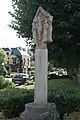 Wegkreuz Croix Catherine
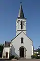 Dorfkirche Saint-Marcel
 Gedenkkreuz Croix du Champ-des-Morts
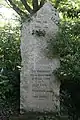 Stele zum Gedenken an getötete Widerstandskämpfer
Literatur
- Le Patrimoine des Communes du Morbihan. Flohic Editions, Band 2, Paris 1996, ISBN 2-84234-009-4, S. 580–583.
Weblinks
Commons: Saint-Marcel – Sammlung von Bildern, Videos und Audiodateien
Einzelnachweise
This article is issued from Wikipedia. The text is licensed under Creative Commons - Attribution - Sharealike. Additional terms may apply for the media files.