Les Pinthières
Les Pinthières ist eine französische Gemeinde mit 161 Einwohnern (Stand: 1. Januar 2021) im Département Eure-et-Loir in der Region Centre-Val de Loire; sie gehört zum Arrondissement Dreux und zum Kanton Épernon. Die Einwohner werden Pinthièrois genannt.
| Les Pinthières | ||
|---|---|---|
| ||
| Staat | Frankreich | |
| Region | Centre-Val de Loire | |
| Département (Nr.) | Eure-et-Loir (28) | |
| Arrondissement | Dreux | |
| Kanton | Épernon | |
| Gemeindeverband | Portes Euréliennes d’Île-de-France | |
| Koordinaten | 48° 42′ N, 1° 34′ O | |
| Höhe | 131–153 m | |
| Fläche | 4,01 km² | |
| Einwohner | 161 (1. Januar 2021) | |
| Bevölkerungsdichte | 40 Einw./km² | |
| Postleitzahl | 28210 | |
| INSEE-Code | 28299 | |
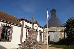 Rathaus (Mairie) von Les Pinthières | ||

Geographie
Les Pinthières liegt etwa 26 Kilometer nordnordwestlich von Chartres. Umgeben wird Les Pinthières von den Nachbargemeinden Boutigny-Prouais im Nordwesten und Norden, Grandchamp im Nordosten, Le Tartre-Gaudran im Osten und Südosten, Faverolles im Süden sowie Saint-Laurent-la-Gâtine im Südwesten und Westen.
Bevölkerungsentwicklung
| Jahr | 1962 | 1968 | 1975 | 1982 | 1990 | 1999 | 2006 | 2020 |
| Einwohner | 60 | 65 | 59 | 55 | 93 | 132 | 169 | 166 |
| Quellen: Cassini und INSEE | ||||||||
Sehenswürdigkeiten
- alte Kirche Saint-Martin
- Burg La Ronce aus dem 13. Jahrhundert
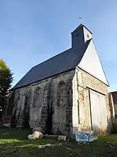
Kirche Saint-Martin
Weblinks
Commons: Les Pinthières – Sammlung von Bildern, Videos und Audiodateien
This article is issued from Wikipedia. The text is licensed under Creative Commons - Attribution - Sharealike. Additional terms may apply for the media files.