Le Fieu
Le Fieu ist eine französische Gemeinde mit 497 Einwohnern (Stand: 1. Januar 2021) im Département Gironde in der Region Nouvelle-Aquitaine. Sie gehört zum Arrondissement Libourne und zum Kanton Le Nord-Libournais. Die Einwohner werden Féodiens genannt.
| Le Fieu | ||
|---|---|---|
| ||
| Staat | Frankreich | |
| Region | Nouvelle-Aquitaine | |
| Département (Nr.) | Gironde (33) | |
| Arrondissement | Libourne | |
| Kanton | Le Nord-Libournais | |
| Gemeindeverband | Libournais | |
| Koordinaten | 45° 4′ N, 0° 2′ W | |
| Höhe | 24–91 m | |
| Fläche | 14,67 km² | |
| Einwohner | 497 (1. Januar 2021) | |
| Bevölkerungsdichte | 34 Einw./km² | |
| Postleitzahl | 33230 | |
| INSEE-Code | 33166 | |
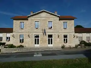 Rathaus von Le Fieu | ||

Geographie
Le Fieu liegt etwa 49 Kilometer nordöstlich von Bordeaux und etwa 23 Kilometer nordöstlich von Libourne. Umgeben wird Le Fieu von den Nachbargemeinden Les Églisottes-et-Chalaures im Norden, Saint-Christophe-de-Double im Osten und Nordosten, Porchères im Osten und Südosten, Coutras im Süden und Südwesten sowie Les Peintures im Westen. Im Süden reicht das Gemeindegebiet bis an die Isle.
Bevölkerungsentwicklung
| Jahr | 1962 | 1968 | 1975 | 1982 | 1990 | 1999 | 2006 | 2013 | 2020 |
| Einwohner | 413 | 465 | 378 | 366 | 379 | 373 | 456 | 517 | 501 |
| Quellen: Cassini und INSEE | |||||||||
Sehenswürdigkeiten
- Neoromanische Kirche Saint-Nicolas mit Bronzeglocke aus dem Jahr 1542
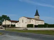
Kirche Saint-Nicolas
Literatur
- Le Patrimoine des Communes de la Gironde. Flohic Éditions, Band 1, Paris 2001, ISBN 2-84234-125-2, S. 623–624.
Weblinks
Commons: Le Fieu – Sammlung von Bildern
This article is issued from Wikipedia. The text is licensed under Creative Commons - Attribution - Sharealike. Additional terms may apply for the media files.