Kanton Boutières
Der Kanton Boutières ist ein französischer Wahlkreis im Arrondissement Yssingeaux, im Département Haute-Loire und in der Region Auvergne-Rhône-Alpes.
| Kanton Boutières | |
|---|---|
| Region | Auvergne-Rhône-Alpes |
| Département | Haute-Loire |
| Arrondissement | Yssingeaux |
| Hauptort | Tence |
| Einwohner | 12.532 (1. Jan. 2021) |
| Bevölkerungsdichte | 38 Einw./km² |
| Fläche | 325,68 km² |
| Gemeinden | 12 |
| INSEE-Code | 4303 |
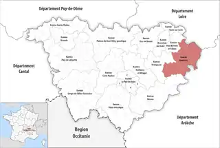 Lage des Kantons Boutières im Département Haute-Loire | |
Gemeinden
Der Kanton besteht aus zwölf Gemeinden mit insgesamt 12.532 Einwohnern (Stand: 2021) auf einer Gesamtfläche von 325,68 km²:
| Gemeinde | Einwohner 1. Januar 2021 |
Fläche km² |
Dichte Einw./km² |
Code INSEE |
Postleitzahl |
|---|---|---|---|---|---|
| Chenereilles | 300 | 14,42 | 21 | 43069 | 43190 |
| Dunières | 2.631 | 34,75 | 76 | 43087 | 43220 |
| Le Mas-de-Tence | 147 | 12,83 | 11 | 43129 | 43190 |
| Montfaucon-en-Velay | 1.143 | 4,99 | 229 | 43141 | 43290 |
| Montregard | 597 | 39,93 | 15 | 43142 | 43290 |
| Raucoules | 944 | 21,01 | 45 | 43159 | 43290 |
| Riotord | 1.184 | 51,88 | 23 | 43163 | 43220 |
| Saint-Bonnet-le-Froid | 214 | 13,09 | 16 | 43172 | 43290 |
| Saint-Jeures | 972 | 34,14 | 28 | 43199 | 43200 |
| Saint-Julien-Molhesabate | 168 | 27,50 | 6 | 43204 | 43220 |
| Saint-Romain-Lachalm | 1.109 | 19,02 | 58 | 43223 | 43620 |
| Tence | 3.123 | 52,12 | 60 | 43244 | 43190 |
| Kanton Boutières | 12.532 | 325,68 | 38 | 4303 | – |
This article is issued from Wikipedia. The text is licensed under Creative Commons - Attribution - Sharealike. Additional terms may apply for the media files.