Kanton Étampes
Der Kanton Étampes ist ein französischer Wahlkreis im Arrondissement Étampes, im Département Essonne und in der Region Île-de-France; sein Hauptort ist Étampes, Vertreter im Generalrat des Départements ist seit 2008 Jean Perthuis (zunächst UMP, dann Parti radical valoisien).
| Kanton Étampes | |
|---|---|
| Region | Île-de-France |
| Département | Essonne |
| Arrondissement | Étampes |
| Hauptort | Étampes |
| Einwohner | 64.867 (1. Jan. 2021) |
| Bevölkerungsdichte | 119 Einw./km² |
| Fläche | 547,08 km² |
| Gemeinden | 44 |
| INSEE-Code | 9108 |
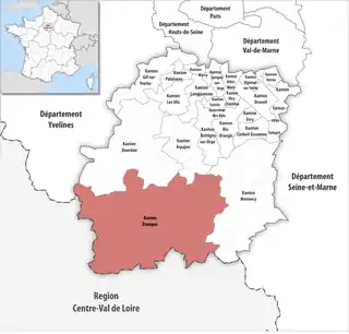 Lage des Kantons Étampes im Département Essonne | |
Gemeinden
Der Kanton besteht aus 44 Gemeinden mit insgesamt 80.622 Einwohnern (Stand: 1. Januar 2021) auf einer Gesamtfläche von 18,46 km²:
| Gemeinde | Einwohner 1. Januar 2021 |
Fläche km² |
Dichte Einw./km² |
Code INSEE |
Postleitzahl |
|---|---|---|---|---|---|
| Abbéville-la-Rivière | 332 | 15,02 | 22 | 91001 | 91150 |
| Angerville | 4.395 | 25,83 | 170 | 91016 | 91670 |
| Arrancourt | 122 | 7,40 | 16 | 91022 | 91690 |
| Authon-la-Plaine | 372 | 10,59 | 35 | 91035 | 91410 |
| Auvers-Saint-Georges | 1.277 | 12,99 | 98 | 91038 | 91580 |
| Blandy | 111 | 7,91 | 14 | 91067 | 91150 |
| Bois-Herpin | 82 | 3,89 | 21 | 91075 | 91150 |
| Boissy-la-Rivière | 517 | 12,47 | 41 | 91079 | 91690 |
| Boissy-le-Cutté | 1.355 | 4,58 | 296 | 91080 | 91590 |
| Boissy-le-Sec | 688 | 19,06 | 36 | 91081 | 91870 |
| Boutervilliers | 430 | 7,01 | 61 | 91098 | 91150 |
| Bouville | 648 | 20,53 | 32 | 91100 | 91880 |
| Brières-les-Scellés | 1.250 | 8,65 | 145 | 91109 | 91150 |
| Brouy | 123 | 8,39 | 15 | 91112 | 91150 |
| Cerny | 3.345 | 17,13 | 195 | 91129 | 91590 |
| Chalo-Saint-Mars | 1.031 | 28,67 | 36 | 91130 | 91780 |
| Chalou-Moulineux | 383 | 10,47 | 37 | 91131 | 91740 |
| Champmotteux | 363 | 7,57 | 48 | 91137 | 91150 |
| Chatignonville | 71 | 5,13 | 14 | 91145 | 91410 |
| Congerville-Thionville | 214 | 8,47 | 25 | 91613 | 91740 |
| D’Huison-Longueville | 1.514 | 10,04 | 151 | 91198 | 91590 |
| Étampes | 26.529 | 40,92 | 648 | 91223 | 91150 |
| Fontaine-la-Rivière | 172 | 3,69 | 47 | 91240 | 91690 |
| Guillerval | 813 | 17,30 | 47 | 91294 | 91690 |
| La Forêt-Sainte-Croix | 158 | 5,36 | 29 | 91248 | 91150 |
| Le Mérévillois | 3.364 | 32,97 | 102 | 91390 | 91660 |
| Marolles-en-Beauce | 238 | 6,00 | 40 | 91374 | 91150 |
| Mérobert | 630 | 10,71 | 59 | 91393 | 91780 |
| Mespuits | 201 | 9,95 | 20 | 91399 | 91150 |
| Monnerville | 378 | 8,31 | 45 | 91414 | 91930 |
| Morigny-Champigny | 4.405 | 30,85 | 143 | 91433 | 91150 |
| Ormoy-la-Rivière | 940 | 10,29 | 91 | 91469 | 91150 |
| Orveau | 151 | 4,30 | 35 | 91473 | 91590 |
| Plessis-Saint-Benoist | 329 | 9,16 | 36 | 91495 | 91410 |
| Puiselet-le-Marais | 261 | 11,27 | 23 | 91508 | 91150 |
| Pussay | 2.169 | 11,55 | 188 | 91511 | 91740 |
| Roinvilliers | 108 | 7,16 | 15 | 91526 | 91150 |
| Saclas | 1.847 | 13,66 | 135 | 91533 | 91690 |
| Saint-Cyr-la-Rivière | 489 | 8,81 | 56 | 91544 | 91690 |
| Saint-Escobille | 473 | 12,00 | 39 | 91547 | 91410 |
| Saint-Hilaire | 405 | 6,79 | 60 | 91556 | 91780 |
| Valpuiseaux | 621 | 18,70 | 33 | 91629 | 91720 |
| Vayres-sur-Essonne | 969 | 8,46 | 115 | 91639 | 91820 |
| Villeneuve-sur-Auvers | 594 | 7,07 | 84 | 91671 | 91580 |
| Kanton Étampes | 64.867 | 547,08 | 119 | 9108 | – |
Bis zur Neuordnung bestand der Kanton Étampes aus den elf Gemeinden Boissy-le-Sec, Boutervilliers, Bouville, Brières-les-Scellés, Chalo-Saint-Mars, Étampes, Morigny-Champigny, Ormoy-la-Rivière, Puiselet-le-Marais, Saint-Hilaire und Valpuiseaux. Sein Zuschnitt entsprach einer Fläche von 202,74 km2.
Bevölkerungsentwicklung
| 1968 | 1975 | 1982 | 1990 | 1999 | 2006 | 2011 |
|---|---|---|---|---|---|---|
| 21.428 | 25.582 | 27.065 | 30.333 | 31.313 | 32.589 | 34.453 |
Veränderungen im Gemeindebestand seit 2016
- 2019: Fusion Estouches und Méréville → Le Mérévillois
This article is issued from Wikipedia. The text is licensed under Creative Commons - Attribution - Sharealike. Additional terms may apply for the media files.