Guillonville
Guillonville ist eine französische Gemeinde mit 461 Einwohnern (Stand: 1. Januar 2021) im Département Eure-et-Loir in der Region Centre-Val de Loire; sie gehört zum Arrondissement Châteaudun und zum Kanton Villages Vovéens.
| Guillonville | ||
|---|---|---|
| ||
| Staat | Frankreich | |
| Region | Centre-Val de Loire | |
| Département (Nr.) | Eure-et-Loir (28) | |
| Arrondissement | Châteaudun | |
| Kanton | Villages Vovéens | |
| Gemeindeverband | Cœur de Beauce | |
| Koordinaten | 48° 6′ N, 1° 40′ O | |
| Höhe | 113–140 m | |
| Fläche | 27,15 km² | |
| Einwohner | 461 (1. Januar 2021) | |
| Bevölkerungsdichte | 17 Einw./km² | |
| Postleitzahl | 28140 | |
| INSEE-Code | 28190 | |
| Website | http://www.mairie-guillonville.fr/ | |
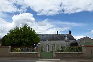 Rathaus Guillonville | ||

Geographie
Guillonville liegt etwa 28 Kilometer nordwestlich von Orléans. Umgeben wird Guillonville von Nachbargemeinden Cormainville im Nordwesten und Norden, Courbehaye im Norden, Orgères-en-Beauce im Norden und Nordosten, Loigny-la-Bataille im Nordosten und Osten, Terminiers im Osten, Patay im Südosten, Villeneuve-sur-Conie im Süden, Péronville im Südwesten sowie Bazoches-en-Dunois im Westen.
Bevölkerungsentwicklung
| Jahr | 1962 | 1968 | 1975 | 1982 | 1990 | 1999 | 2006 | 2013 | 2020 |
| Einwohner | 600 | 502 | 463 | 487 | 434 | 419 | 456 | 439 | 459 |
| Quellen: Cassini und INSEE | |||||||||
Sehenswürdigkeiten
- Kirche Saint-Pierre
- protestantische Kirche von 1884 in Gaubert
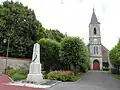 Kirche Saint-Pierre und Gefallenendenkmal
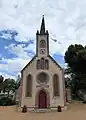 Protestantische Kirche in Gaubert
Weblinks
Commons: Guillonville – Sammlung von Bildern
This article is issued from Wikipedia. The text is licensed under Creative Commons - Attribution - Sharealike. Additional terms may apply for the media files.