Gendreville
Gendreville ist eine französische Gemeinde im Département Vosges in der Region Grand Est (bis 2015 Lothringen). Sie gehört zum Kanton Vittel im Arrondissement Neufchâteau.
| Gendreville | ||
|---|---|---|
| ||
| Staat | Frankreich | |
| Region | Grand Est | |
| Département (Nr.) | Vosges (88) | |
| Arrondissement | Neufchâteau | |
| Kanton | Vittel | |
| Gemeindeverband | Terre d’Eau | |
| Koordinaten | 48° 14′ N, 5° 43′ O | |
| Höhe | 312–480 m | |
| Fläche | 8,08 km² | |
| Einwohner | 103 (1. Januar 2021) | |
| Bevölkerungsdichte | 13 Einw./km² | |
| Postleitzahl | 88140 | |
| INSEE-Code | 88195 | |
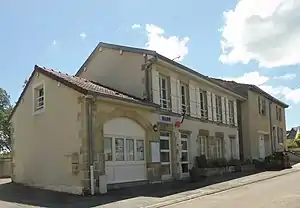 Mairie Gendreville | ||

Geografie
Gendreville liegt am Fluss Anger an der Grenze zum Département Haute-Marne. Sie grenzt im Nordosten an Beaufremont, im Osten an Malaincourt, im Südosten an Médonville, im Südwesten an Outremécourt, im Westen an Sartes und im Nordwesten an Jainvillotte.
Bevölkerungsentwicklung
| Jahr | 1962 | 1968 | 1975 | 1982 | 1990 | 1999 | 2008 | 2019 |
|---|---|---|---|---|---|---|---|---|
| Einwohner | 154 | 156 | 140 | 145 | 127 | 109 | 113 | 105 |
Sehenswürdigkeiten
- Kirche Saint-Rémi
- Kapellen Saint-Charles und Notre-Dame-de-Bonsecours
- Wegkreuz, Monument historique
- Gefallenendenkmal
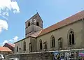 Kirche Saint-Rémi
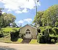 Kapelle Notre-Dame-de-Bon-Secours
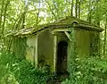 Kapelle Saint-Charles
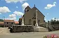 Wegkreuz und Gefallenendenkmal
Weblinks
Commons: Gendreville – Sammlung von Bildern, Videos und Audiodateien
This article is issued from Wikipedia. The text is licensed under Creative Commons - Attribution - Sharealike. Additional terms may apply for the media files.