Concressault
| Concressault | ||
|---|---|---|
|
| |
| Staat | Frankreich | |
| Region | Centre-Val de Loire | |
| Département (Nr.) | Cher (18) | |
| Arrondissement | Bourges | |
| Kanton | Sancerre | |
| Gemeindeverband | Pays Fort Sancerrois Val de Loire | |
| Koordinaten | 47° 29′ N, 2° 35′ O | |
| Höhe | 175–272 m | |
| Fläche | 7,45 km² | |
| Einwohner | 200 (1. Januar 2021) | |
| Bevölkerungsdichte | 27 Einw./km² | |
| Postleitzahl | 18260 | |
| INSEE-Code | 18070 | |

Concressault ist eine französische Gemeinde mit 200 Einwohnern (Stand: 1. Januar 2021) im Département Cher in der Region Centre-Val de Loire. Sie gehört zum Arrondissement Bourges und zum Kanton Sancerre.
Lage
 die Sauldre in Concressault |
Concressault liegt an der oberen Sauldre, etwa 53 Kilometer nordnordöstlich von Bourges. Umgeben wird Concressault von den Nachbargemeinden Blancafort im Norden, Barlieu im Osten, Dampierre-en-Crot im Süden sowie Oizon im Südwesten und Westen.
Bevölkerungsentwicklung
| Jahr | 1962 | 1968 | 1975 | 1982 | 1990 | 1999 | 2006 | 2019 |
| Einwohner | 298 | 261 | 232 | 216 | 236 | 214 | 224 | 202 |
| Quellen: Cassini und INSEE | ||||||||
Sehenswürdigkeiten
- Kirche Saint-Pierre, seit 2006 Monument historique
- Domäne Le Moulin-Riche aus dem 16. Jahrhundert
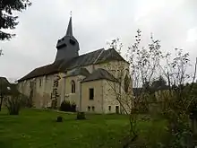
Kirche Saint-Pierre
Literatur
- Le Patrimoine des Communes du Cher. Flohic Editions, Band 2, Paris 2001, ISBN 2-84234-088-4, S. 996–1000.
Weblinks
Commons: Concressault – Sammlung von Bildern, Videos und Audiodateien
This article is issued from Wikipedia. The text is licensed under Creative Commons - Attribution - Sharealike. Additional terms may apply for the media files.