Charbonnières (Saône-et-Loire)
Charbonnières ist eine französische Gemeinde mit 329 Einwohnern (Stand: 1. Januar 2021) im Département Saône-et-Loire in der Region Bourgogne-Franche-Comté. Sie gehört zum Arrondissement Mâcon und zum Kanton Hurigny (bis 2015: Kanton Mâcon-Nord). Die Einwohner werden Leunais genannt.
| Charbonnières | ||
|---|---|---|
| ||
| Staat | Frankreich | |
| Region | Bourgogne-Franche-Comté | |
| Département (Nr.) | Saône-et-Loire (71) | |
| Arrondissement | Mâcon | |
| Kanton | Hurigny | |
| Gemeindeverband | Mâconnais Beaujolais Agglomération | |
| Koordinaten | 46° 23′ N, 4° 50′ O | |
| Höhe | 181–277 m | |
| Fläche | 4,17 km² | |
| Einwohner | 329 (1. Januar 2021) | |
| Bevölkerungsdichte | 79 Einw./km² | |
| Postleitzahl | 71260 | |
| INSEE-Code | 71099 | |

Geographie
Charbonnières liegt etwa neun Kilometer nördlich von Mâcon in der Mâconnais und im Weinbaugebiet Bourgogne. Das Gemeindegebiet wird vom Fluss Mouge durchquert. Umgeben wird Charbonnières von den Nachbargemeinden Clessé im Norden und Nordwesten, La Salle im Norden und Nordosten, Senozan im Nordosten, Saint-Martin-Belle-Roche im Osten und Südosten, Mâcon im Süden sowie Laizé im Westen.
Bevölkerungsentwicklung
| Jahr | 1962 | 1968 | 1975 | 1982 | 1990 | 1999 | 2006 | 2013 |
| Einwohner | 162 | 178 | 168 | 262 | 280 | 322 | 324 | 358 |
| Quelle: Cassini und INSEE | ||||||||
Sehenswürdigkeiten
- Kirche Saint-Bonnet
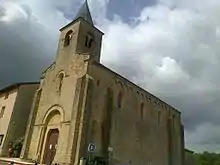
Kirche Saint-Bonnet
Weblinks
Commons: Charbonnières – Sammlung von Bildern, Videos und Audiodateien
This article is issued from Wikipedia. The text is licensed under Creative Commons - Attribution - Sharealike. Additional terms may apply for the media files.