Chapakot
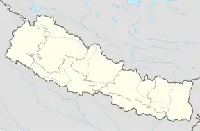
Chapakot (Nepali चापाकोट Chapakot) ist eine Stadt (Munizipalität) im Distrikt Syangja in Zentral-Nepal.
| Chapakot Nagarpalika चापाकोट नगरपालिका Chapakot | |||
|---|---|---|---|
| |||
| Koordinaten | 27° 53′ 11″ N, 83° 49′ 18″ O | ||
| Basisdaten | |||
| Staat | Nepal | ||
| Provinz | Gandaki | ||
| Distrikt | Syangja | ||
| Höhe | 400 m | ||
| Fläche | 49,2 km² | ||
| Einwohner | 12.742 (2011) | ||
| Dichte | 259 Ew./km² | ||
| Gründung | 18. Mai 2014 | ||
| Website | www.chapakotmun.gov.np | ||
| Politik | |||
| Chief Executive Officer | Gopi Krishna Aryal (Oktober 2015) | ||
| 14 Wards | |||
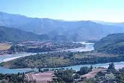 | |||
Die Stadt entstand 2014 durch Zusammenlegung der Village Development Committees Chapakot, Kuwakot und Ratnapur.[1][2] Chapakot liegt am linken nördlichen Flussufer des Unterlaufs des Kali Gandaki oberhalb der Einmündung des Jagdee Khola. Das Stadtgebiet umfasst 49,2 km².[3]
Einwohner
Bei der Volkszählung 2011 hatten die VDCs, aus welchen die Stadt Chapakot entstand, 12.742 Einwohner (davon 5396 männlich) in 2902 Haushalten.[4]
Weblinks
Commons: Chapakot – Sammlung von Bildern, Videos und Audiodateien
Einzelnachweise
- 72 new municipalities announced. My Republica.com, abgerufen am 10. Juni 2014.
- Government announces 72 new municipalities. The Kathmandu Post, archiviert vom am 6. Oktober 2014; abgerufen am 16. März 2024.
- Municipal Association of Nepal (MuAN) ( vom 7. Januar 2014 im Internet Archive). Abgerufen am 8. April 2024.
- National Population and Housing Census 2011. (PDF) Central Bureau of Statistics, archiviert vom am 31. Juli 2013.
This article is issued from Wikipedia. The text is licensed under Creative Commons - Attribution - Sharealike. Additional terms may apply for the media files.