Bourthes
Bourthes (flämisch: Boorte) ist eine französische Gemeinde mit 842 Einwohnern (Stand: 1. Januar 2021) im Département Pas-de-Calais in der Region Hauts-de-France (vor 2016: Nord-Pas-de-Calais). Sie gehört zum Arrondissement Montreuil und zum Kanton Lumbres (bis 2015: Kanton Hucqueliers).
| Bourthes | ||
|---|---|---|
|
| |
| Staat | Frankreich | |
| Region | Hauts-de-France | |
| Département (Nr.) | Pas-de-Calais (62) | |
| Arrondissement | Montreuil | |
| Kanton | Lumbres | |
| Gemeindeverband | Haut Pays du Montreuillois | |
| Koordinaten | 50° 36′ N, 1° 56′ O | |
| Höhe | 112–183 m | |
| Fläche | 22,33 km² | |
| Einwohner | 842 (1. Januar 2021) | |
| Bevölkerungsdichte | 38 Einw./km² | |
| Postleitzahl | 62650 | |
| INSEE-Code | 62168 | |
.jpg.webp) Mairie (Bürgermeisteramt) | ||

Die Einwohner werden Bourthois genannt.
Geographie
Bourthes liegt etwa 26 Kilometer südöstlich von Boulogne-sur-Mer am Aa.
Nachbargemeinden
Umgeben ist Bourthes von den Nachbargemeinden Senlecques im Norden, Ledinghem im Nordosten, Campagne-lès-Boulonnais im Osten, Ergny im Osten und Südosten, Wicquinghem im Süden und Südosten, Hucqueliers im Süden, Preures im Südwesten, Bezinghem und Zoteux im Westen sowie Preures im Westen.
Bevölkerungsentwicklung
| Jahr | 1962 | 1968 | 1975 | 1982 | 1990 | 1999 | 2006 | 2013 | 2020 |
| Einwohner | 697 | 676 | 722 | 703 | 629 | 545 | 646 | 848 | 841 |
| Quelle: Cassini und INSEE | |||||||||
Sehenswürdigkeiten
- Kirche Saint-Pierre
- Kapelle Sainte-Marthe
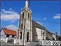 Kirche Saint-Pierre
 Kapelle Sainte-Marthe
Weblinks
Commons: Bourthes – Sammlung von Bildern, Videos und Audiodateien
This article is issued from Wikipedia. The text is licensed under Creative Commons - Attribution - Sharealike. Additional terms may apply for the media files.