Boissy-le-Châtel
Boissy-la-Châtel ist eine französische Gemeinde mit 3285 Einwohnern (Stand: 1. Januar 2021) im Département Seine-et-Marne in der Region Île-de-France. Sie gehört zum Arrondissement Meaux und zum Kanton Coulommiers. Die Einwohner werden Buccéens genannt.
| Boissy-le-Châtel | ||
|---|---|---|

|
| |
| Staat | Frankreich | |
| Region | Île-de-France | |
| Département (Nr.) | Seine-et-Marne (77) | |
| Arrondissement | Meaux | |
| Kanton | Coulommiers | |
| Gemeindeverband | Coulommiers Pays de Brie | |
| Koordinaten | 48° 49′ N, 3° 8′ O | |
| Höhe | 72–150 m | |
| Fläche | 9,95 km² | |
| Einwohner | 3.285 (1. Januar 2021) | |
| Bevölkerungsdichte | 330 Einw./km² | |
| Postleitzahl | 77169 | |
| INSEE-Code | 77042 | |
| Website | http://www.boissy-le-chatel.fr/ | |
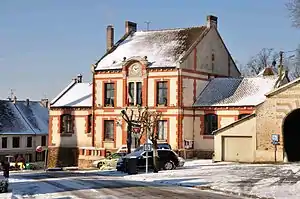 Rathaus von Boissy-la-Châtel | ||

Geographie
Boissy-la-Châtel liegt in der historischen Region Brie am Fluss Grand Morin. Umgeben wird Boissy-la-Châtel von den Nachbargemeinden Saint-Germain-sous-Doue im Norden, Saint-Denis-lès-Rebais im Nordosten, Chauffry im Osten, Chailly-en-Brie im Süden, Coulommiers im Westen sowie Aulnoy im Nordwesten.
Bevölkerungsentwicklung
| Jahr | 1962 | 1968 | 1975 | 1982 | 1990 | 1999 | 2006 | 2011 |
| Einwohner | 1271 | 1284 | 1393 | 1725 | 2366 | 2661 | 3014 | 3110 |
Sehenswürdigkeiten
Siehe auch: Liste der Monuments historiques in Boissy-le-Châtel
- Kirche Saint-Sulpice aus dem 13. Jahrhundert
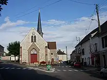
Kirche Saint-Sulpice
Literatur
- Le Patrimoine des Communes de la Seine-et-Marne. Flohic Editions, Band 1, Paris 2001, ISBN 2-84234-100-7, S. 317–318.
Weblinks
Commons: Boissy-le-Châtel – Sammlung von Bildern, Videos und Audiodateien
This article is issued from Wikipedia. The text is licensed under Creative Commons - Attribution - Sharealike. Additional terms may apply for the media files.