Loumate
Loumate ist ein osttimoresischer Ort in der Aldeia Fatubesi (Suco Atabae, Verwaltungsamt Atabae, Gemeinde Bobonaro). Er liegt in einer Meereshöhe von 76 m.[1][2]
| Loumate | |||
|---|---|---|---|
| |||
| Koordinaten | 8° 49′ S, 125° 12′ O | ||
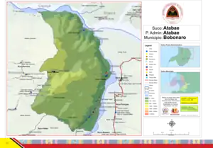 Der Suco Atabae | |||
| Basisdaten | |||
| Staat | Osttimor | ||
| Gemeinde | Bobonaro | ||
| Verwaltungsamt | Atabae | ||
| Suco | Atabae | ||
| Aldeia | Fatubesi | ||
| Höhe | 76 m | ||
Die Siedlung liegt direkt am Fluss Nunura, an der Ostgrenze von Fatubesi. Im Norden wird sie nur durch einen Bach von Lugu Teho abgetrennt. Der Bach im Süden trennt Loumate vom Nachbarort Daarobou.[2]
Einzelnachweise
- Direcção-Geral de Estatística: Atlas der Gemeinde Bobonaro ( vom 14. August 2022 im Internet Archive), abgerufen am 25. September 2022.
- Timor-Leste GIS-Portal ( vom 30. Juni 2007 im Internet Archive)
This article is issued from Wikipedia. The text is licensed under Creative Commons - Attribution - Sharealike. Additional terms may apply for the media files.